
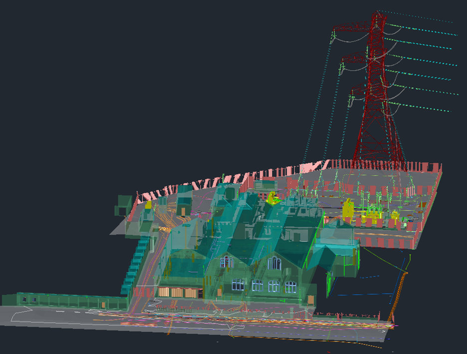
Precision Utility Mapping was employed to carry out a full Revit model of Blackhall Substation prior to demolition of the existing building. This was to be used as part of cable diversion and phased demolition.
Scope of Work
The scope of services included:
- Topographical Survey: Mapping existing pavements, roads, tracks, footways, boundary features, surface changes, and other site details.
- Utility Survey: Identification of all services within the designated survey area, including underground electrical, communications, water, and drainage networks.
- Laser Scanning: A fully referenced laser scan was carried out encompassing the external features and cable basement.
Survey Methodology
A combination of advanced geospatial techniques and traditional surveying methods was employed to achieve precise and comprehensive results.
- Topographical Data Collection
- Utilized GNSS receivers, total stations, and laser scanning for high-accuracy mapping.
- Data referenced to National Grid and Level Datum.
- Deliverables prepared in AutoCAD, Revit and PDF formats.
- Utility Detection & Mapping
- Geophysical survey instruments, including Ground Penetrating Radar (GPR) and electromagnetic locators, were used to detect and map underground utilities.
- Detailed utility attribute data was recorded, including pipe and cable depths, diameters, and cable circuit names.
- Revit Model
- 3D laser scan data was converted into a Revit model.
- Cable/circuit names were designated against all trace cables.
- Cable routes within the basement were carefully mapped throughout the full basement allowing the exact routing to be determined.
- Cable route information will be critical during the diversion works prior to demolition.
Challenges & Solutions
- Basement Scanning: Access to the basement was via a small spiral staircase this, along with the multiple rooms and poor lighting, made referencing the scan data a challenge. We overcame this through careful planning and installation of control.
- Congested Cable Routes: As to be expected, the substation was densely packed with underground HV cables. From within the basement, we were able to track each individual cable and, using the cable identifiers, we were able to track the route of each cable through the basement and the full route within the substation. This information was then tagged within the Revit model.
- Weather Sensitivity: The efficiency of Ground Penetrating Radar was impacted by wet conditions. Survey schedules were adjusted accordingly to optimize data capture quality.
Project Deliverables
- 2D and 3D topographical drawings in DWG and PDF formats.
- Utility survey report including metadata, detection methodology evaluation, and a list of undetected expected utilities.
- Revit model.
Client Impact & Outcome
The successful completion of the this survey has allowed our client to plan the works accordingly and safely. We will be continuing to work with the client to update the model as the works progress. This will be done by removing the cables from the model as they are de-energised.
This project exemplifies Precision Utility Mapping’s ability to deliver multi-faceted geospatial solutions tailored to complex infrastructure environments.
Bethell Construction
Andrew Reid
michael.oconnor@bethell.co.uk
Start Date: 9th May 2025
End Date: 29th August 2025
Contract Value: £40,000