
Precision Utility Mapping was engaged to conduct a comprehensive topographical and utility survey at Ringway Road, with the aim of capturing detailed site data to inform infrastructure planning and development. The survey encompassed topographical features, utility detection, and drainage assessment.
Scope of Work
The scope of services included:
- Topographical Survey: Mapping existing pavements, roads, tracks, footways, boundary features, surface changes, and other site details.
- Utility Survey: Identification of all services within the designated survey area, including underground electrical, communications, water, and drainage networks.
- CCTV Drainage Survey: Inspection and assessment of drainage systems to record live flow rates and conditions.
Survey Methodology
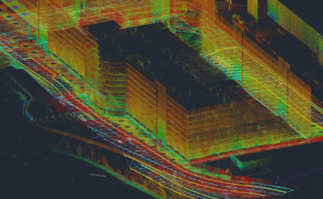
A combination of advanced geospatial techniques and traditional surveying methods was employed to achieve precise and comprehensive results.
- Topographical Data Collection
- Utilized GNSS receivers, total stations, and laser scanning for high-accuracy mapping.
- Pavement surveys conducted with a precision tolerance of +/-3mm.
- Data referenced to National Grid and Level Datum.
- Deliverables prepared in AutoCAD 2013 and PDF formats.
- Utility Detection & Mapping
- Geophysical survey instruments, including Ground Penetrating Radar (GPR) and electromagnetic locators, were used to detect and map underground utilities.
- Detailed utility attribute data was recorded, including pipe and cable depths, diameters, and material types.
- Plan and descriptions were created for the success rate of detection methodologies.
- Uncharted and redundant services were identified and documented.
- Drainage Assessment & CCTV Survey
- Inspection of drainage networks using robotic CCTV cameras.
- Digital records of chamber conditions, obstructions, and flow rates were maintained.
- Identified and reported any chambers that could not be accessed.
- Photographs and chamber cards were prepared for all accessible drainage features.
Challenges & Solutions
- Restricted Access Areas: Certain areas, such as internal sections of the Multi-Storey Car Park (MSCP), were inaccessible. To mitigate this, tracing techniques were used to identify utilities traversing these sections.
- Utility Record Gaps: Some utility records were incomplete. A combination of historical data review and on-site detection ensured accurate mapping.
- Weather Sensitivity: The efficiency of Ground Penetrating Radar was impacted by wet conditions. Survey schedules were adjusted accordingly to optimize data capture quality.
Project Deliverables
- 2D and 3D topographical drawings in DWG and PDF formats.
- Utility survey report including metadata, detection methodology evaluation, and a list of undetected expected utilities.
- CCTV survey data with drainage condition assessments and flow rate analysis.
- Comprehensive GIS-compatible dataset for client integration.
Client Impact & Outcome
The successful completion of the Ringway Road survey provided a highly accurate dataset for future infrastructure development and maintenance planning. The integration of topographical, utility, and drainage data ensured a holistic understanding of site conditions, enabling the client to make informed decisions regarding asset management and construction planning.
This project exemplifies Precision Utility Mapping’s ability to deliver multi-faceted geospatial solutions tailored to complex infrastructure environments.
Bethell Construction
Mike O’Connor
michael.oconnor@bethell.co.uk
Start Date: 18th April 2024
End Date: 3rd May 2024
Contract Value: £25,000